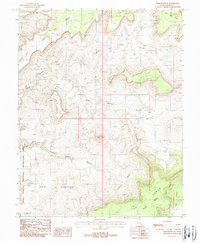
1988 Map of Fiddler Butte
USGS Topo · Published 1988About this map
Fiddler Butte rises as a central landmark in this high desert landscape, which was documented during the late 1980s. The topography is dominated by deep drainage systems and high plateaus, including North Hatch Canyon and South Hatch Canyon. These canyons cut through the terrain toward the Glen Canyon National Recreation Area, which occupies the western and southern portions of the sheet. Evidence of human activity is sparse but specific, with a remote Landing Strip positioned near Buckacre Point. Geologic exploration is noted through several mineral extraction points, such as a named Prospect, a Drill Hole, and an Adit near the canyon rims. Large-scale features like the Red Benches and The Block illustrate the expansive plateau systems typical of the Colorado Plateau, while isolated water sources are marked simply as Spring.
Find a feature on this map
20 named features on this map. Tap any name to fly to it.
Don’t see what you’re looking for? This feature index may not catch every label — zoom into the map to look around manually.
Map Details
Editions of this 1988 Fiddler Butte Map
This is the sole edition of this map. No revisions or reprints were ever made.
Other maps of this area

1885 · San Rafael
USGS Topo · 1:250,000

1886 · Henry Mountains
USGS Topo · 1:250,000

1892 · Henry Mountains
USGS Topo · 1:250,000

1952 · Mouth of Dark Canyon
USGS Topo · 1:62,500

1952 · Orange Cliffs 3 SW
USGS Topo · 1:24,000

1952 · Hite
USGS Topo · 1:62,500

1953 · Orange Cliffs 3 SE
USGS Topo · 1:24,000

1953 · Orange Cliffs 4 NW
USGS Topo · 1:24,000

1953 · Orange Cliffs 3 NE
USGS Topo · 1:24,000

1953 · Orange Cliffs 4 SW
USGS Topo · 1:24,000