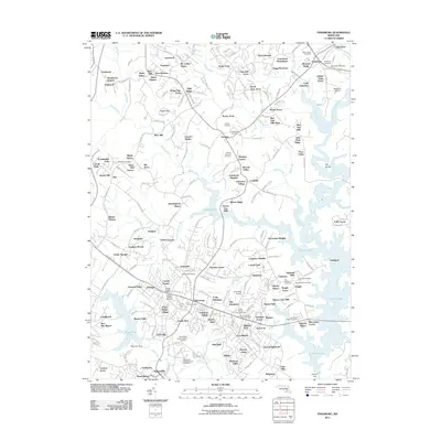
2011 Map of Finksburg
USGS Topo · Published 2011About this map
The expansive Liberty Lake reservoir dominates the landscape of southeastern Carroll County, its winding shoreline shaping the development of modern residential clusters and agricultural remnants. This 2011 survey reveals a transition from traditional rural landmarks to suburban expansion, anchored by the massive presence of the Springfield State Hospital and its associated grounds. For genealogists and local historians, the map is remarkably dense with burial sites, documenting everything from the large Lakeview Memorial Park to historic denominational plots like Wesley Chapel Cemetery and the Springfield State Hospital Cemetery. Settlement patterns follow the historic corridors of Old Liberty RD and Old Westminster Pike, where older hubs like Finksburg meet newer developments such as Eldersburg and Sykesville. Small private airstrips like Hoby Wolf Airport and the specialized Reservoir Airport highlight the region's aviation history, while orchards and named valleys like Emerald Valley suggest the area's agricultural heritage before the intensification of 21st-century growth.
Find a feature on this map
237 named features on this map. Tap any name to fly to it.
Don’t see what you’re looking for? This feature index may not catch every label — zoom into the map to look around manually.
Map Details
Editions of this 2011 Finksburg Map
This is the sole edition of this map. No revisions or reprints were ever made.
Other maps of this area

1892 · Ellicott
USGS Topo · 1:62,500

1893 · Frederick
USGS Topo · 1:125,000

1894 · Ellicott
USGS Topo · 1:62,500

1894 · Frederick
USGS Topo · 1:125,000

1905 · Westminster
USGS Topo · 1:62,500

1906 · Ellicott
USGS Topo · 1:62,500

1908 · Patapsco
USGS Topo · 1:125,000

1909 · Mount Airy
USGS Topo · 1:62,500

1911 · Taneytown
USGS Topo · 1:62,500

1942 · Gettysburg
USGS Topo · 1:125,000