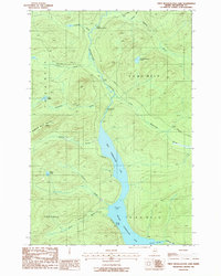
1986 Map of First Musquacook Lake
USGS Topo · Published 1987About this map
First Musquacook Lake and its sister water body, Second Musquacook Lake, anchor this remote reach of the Maine North Woods during the mid-1980s. The landscape is defined by the Musquacook Stream corridor, which connects these lakes through a series of significant whitewater features including Horse Race Rapids and Lower Horse Race Rapids. This 1986 survey documents a working forest environment within the W.E.L.S. townships, where a network of private roads provides the only access to landmarks like Porters Spring and the southern slopes of Shepherd Mountain. Unlike more settled regions, the human footprint here is limited to resource extraction points such as a Gravel Pit and Shale Pit, as well as numerous family-named brooks including McCluskey Brook, Campbell Brook, and Searway Brook that drain the high ground into the central basin.
Find a feature on this map
29 named features on this map. Tap any name to fly to it.
Don’t see what you’re looking for? This feature index may not catch every label — zoom into the map to look around manually.
Map Details
Editions of this 1986 First Musquacook Lake Map
This is the sole edition of this map. No revisions or reprints were ever made.
Other maps of this area

1932 · Umsaskis Lake
USGS Topo · 1:48,000

1932 · Musquacook Lakes
USGS Topo · 1:48,000

1932 · Allagash Falls
USGS Topo · 1:48,000

1935 · Umsaskis Lake
USGS Topo · 1:62,500

1935 · Musquacook Lakes
USGS Topo · 1:62,500

1935 · Allagash Falls
USGS Topo · 1:62,500

1954 · Presque Isle
USGS Topo · 1:250,000

1955 · Round Pond
USGS Topo · 1:62,500

1956 · Allagash Falls
USGS Topo · 1:50,000

1958 · Presque Isle
USGS Topo · 1:250,000