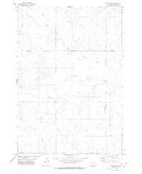
1978 Map of Fish Draw
USGS Topo · Published 1978About this map
The North Fork Moreau River meanders across this landscape in the late 1970s, defining a region of South Dakota characterized by its intricate drainage systems and sparse human infrastructure. This survey illustrates the convergence of numerous seasonal and perennial waterways, including Fish Draw, Sweetwater Draw, and Cottonwood Creek. The boundary between Harding Co and Butte Co bisects the northern half of the sheet, while the lower portion is marked by the presence of the Union area. Evidence of livestock management or early exploration is found in the simple Trail and a solitary Well located east of North Fork Fish Draw. The map is particularly useful for understanding the natural topographical barriers that influenced early settlement and grazing patterns along Hay Creek and Palmer Draw.
Find a feature on this map
13 named features on this map. Tap any name to fly to it.
Don’t see what you’re looking for? This feature index may not catch every label — zoom into the map to look around manually.
Map Details
Editions of this 1978 Fish Draw Map
This is the sole edition of this map. No revisions or reprints were ever made.
Other maps of this area

1935 · Hoover
USGS Topo · 1:125,000

1954 · Lemmon
USGS Topo · 1:250,000

1957 · Lemmon
USGS Topo · 1:250,000

1968 · Irish Butte
USGS Topo · 1:24,000

1968 · Sheep Mountain
USGS Topo · 1:24,000
1973 · Deers Ears Butte North
USGS Topo · 1:24,000
1978 · Porter Creek
USGS Topo · 1:24,000
1978 · Tomato Can Buttes
USGS Topo · 1:24,000

1980 · Redig
USGS Topo · 1:100,000

1980 · Beverly Creek
USGS Topo · 1:25,000