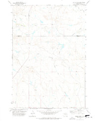
1978 Map of Porter Creek
USGS Topo · Published 1978About this map
The North Fork Moreau River cuts through the northernmost edge of this high plains landscape, anchoring a drainage system that defines the local topography. This 1978 survey highlights the border region of Harding Co and Butte Co, where the environment is dictated by seasonal watercourses and expansive rangeland. The map illustrates a complex network of intermittent streams, including Cottonwood Creek, South Cottonwood Creek, and Porter Creek, which carve winding paths across the terrain.
Find a feature on this map
8 named features on this map. Tap any name to fly to it.
Don’t see what you’re looking for? This feature index may not catch every label — zoom into the map to look around manually.
Map Details
Editions of this 1978 Porter Creek Map
This is the sole edition of this map. No revisions or reprints were ever made.
Other maps of this area

1935 · Hoover
USGS Topo · 1:125,000

1954 · Lemmon
USGS Topo · 1:250,000

1957 · Lemmon
USGS Topo · 1:250,000

1968 · Irish Butte
USGS Topo · 1:24,000

1968 · Sheep Mountain
USGS Topo · 1:24,000
1973 · Deers Ears Butte North
USGS Topo · 1:24,000
1977 · Hoover
USGS Topo · 1:24,000
1977 · Granger Creek
USGS Topo · 1:24,000
1978 · Bams Butte SE
USGS Topo · 1:24,000
1978 · Fish Draw
USGS Topo · 1:24,000