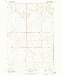
1977 Map of Hoover
USGS Topo · Published 1978About this map
Hoover sits at the northern edge of this landscape, a lone settlement where the Moreau River and South Fork Moreau River converge. This western South Dakota terrain is defined by an intricate drainage system, with Bull Creek, Frog Creek, and Hans Creek carving winding paths through the high plains. The confluence at Hoover highlights a traditional focal point for habitation in a region otherwise dominated by wide-open ranching land and seasonal waterways like Badlands Creek and Sand Creek. The 1970s road network is anchored by Route 79, providing a primary north-south artery through Butte County. The map captures the subtle relief of the Missouri Plateau, showing the complex web of draws and forks that feed the larger Moreau basin.
Find a feature on this map
9 named features on this map. Tap any name to fly to it.
Don’t see what you’re looking for? This feature index may not catch every label — zoom into the map to look around manually.
Map Details
Editions of this 1977 Hoover Map
This is the sole edition of this map. No revisions or reprints were ever made.
Other maps of this area

1913 · Newell
USGS Topo · 1:125,000

1935 · Hoover
USGS Topo · 1:125,000

1953 · Rapid City
USGS Topo · 1:250,000

1954 · Lemmon
USGS Topo · 1:250,000

1957 · Lemmon
USGS Topo · 1:250,000

1957 · Rapid City
USGS Topo · 1:250,000

1973 · Lone Tree Draw East
USGS Topo · 1:24,000
1973 · Deers Ears Butte North
USGS Topo · 1:24,000
1973 · Haystack Butte
USGS Topo · 1:24,000
1977 · Castle Rock
USGS Topo · 1:24,000