
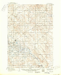
1913 Map of Newell
USGS Topo · Published 1913About this map
The Belle Fourche River winds through this western South Dakota landscape during a period of significant agricultural and infrastructure development. The arrival of the Chicago and Northwestern Ry anchored the town of Newell, which serves as a central hub near the Butte Co Meade Co Boundary Line. An intriguing historical layer is added by the inclusion of irrigation ditches from the Belle Fourche project, noted in the margin as being based on 1913 data from the U.S. Reclamation Service, reflecting the era's push to transform the plains through water management.
Find a feature on this map
29 named features on this map. Tap any name to fly to it.
Don’t see what you’re looking for? This feature index may not catch every label — zoom into the map to look around manually.
Map Details
Editions of this 1913 Newell Map
2 editions found
Other maps of this area

1893 · Rapid
USGS Topo · 1:125,000

1894 · Deadwood
USGS Topo · 1:125,000

1898 · Rapid
USGS Topo · 1:125,000

1899 · Sturgis
USGS Topo · 1:62,500

1901 · Deadwood
USGS Topo · 1:125,000

1903 · Rapid
USGS Topo · 1:125,000

1905 · Saint Onge
USGS Topo · 1:62,500

1906 · Two Top
USGS Topo · 1:62,500

1906 · Vale
USGS Topo · 1:62,500

1907 · Belle Fourche
USGS Topo · 1:125,000