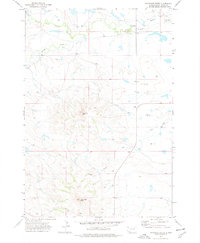
1973 Map of Haystack Butte
USGS Topo · Published 1978About this map
Haystack Butte and Castle Rock Butte dominate this section of the South Dakota plains, serving as prominent geological landmarks in a landscape defined by expansive ranching and grazing land. During the early 1970s, the rural character of this region remained largely intact, with isolated developments like the Moreau Sch providing essential services for the scattered local population. The drainage patterns are dictated by the South Fork Moreau River in the north and the meandering courses of Battle Creek and Bull Creek, which carve subtle valleys through the prairie. Family-named locations such as Deschamps highlight the area's history of private landholding and settlement in the high plains environment of Butte County.
Find a feature on this map
7 named features on this map. Tap any name to fly to it.
Don’t see what you’re looking for? This feature index may not catch every label — zoom into the map to look around manually.
Map Details
Editions of this 1973 Haystack Butte Map
2 editions found
Other maps of this area

1906 · Two Top
USGS Topo · 1:62,500

1907 · Belle Fourche
USGS Topo · 1:125,000

1913 · Newell
USGS Topo · 1:125,000

1935 · Hoover
USGS Topo · 1:125,000

1935 · Harding
USGS Topo · 1:125,000

1953 · Rapid City
USGS Topo · 1:250,000

1954 · Lemmon
USGS Topo · 1:250,000

1957 · Lemmon
USGS Topo · 1:250,000

1957 · Rapid City
USGS Topo · 1:250,000
1965 · Two Top Butte East
USGS Topo · 1:24,000