
1906 Map of Two Top
USGS Topo · Published 1906About this map
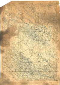
Two Top Peak dominates the northern skyline of this 1906 advance sheet, serving as a primary landmark in a landscape defined by the drainage basins of western South Dakota. The survey reveals a sparsely settled territory during the early twentieth century, where water sources dictated the placement of early homesteads and infrastructure. A notable point of human activity is Road Ranch, positioned centrally among the network of creek beds. The map meticulously traces the winding paths of Indian Creek, Willow Creek, and Horse Creek, illustrating how these waterways carved the terrain. This period of mapping, overseen by Charles D. Walcott, provides a detailed view of the region before significant modern development, capturing the original surveyor's points and benchmarks used to navigate the open range of Butte County.
Find a feature on this map
14 named features on this map. Tap any name to fly to it.
Don’t see what you’re looking for? This feature index may not catch every label — zoom into the map to look around manually.
Map Details
Editions of this 1906 Two Top Map
This is the sole edition of this map. No revisions or reprints were ever made.
Other maps of this area

1905 · Saint Onge
USGS Topo · 1:62,500
1905 · Indian
USGS Topo · 1:62,500

1906 · Vale
USGS Topo · 1:62,500

1907 · Belle Fourche
USGS Topo · 1:125,000
1907 · Redwater
USGS Topo · 1:62,500

1913 · Newell
USGS Topo · 1:125,000

1935 · Hoover
USGS Topo · 1:125,000

1935 · Harding
USGS Topo · 1:125,000
1951 · Newell
USGS Topo · 1:24,000
1951 · Nisland
USGS Topo · 1:24,000