
1907 Map of Belle Fourche
USGS Topo · Published 1907About this map
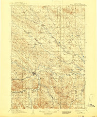
Belle Fourche serves as the hub of this early twentieth-century ranching and transit landscape, situated at the confluence of the Belle Fourche River and Redwater Creek. The settlement pattern of the Black Hills foothills is clearly defined by early cattle operations and road stops, including O Connors Ranch, Brants Road Ranch, and Indian Road Ranch. These scattered outposts highlight the region's reliance on established trails and the Chicago and Northwestern RR, which snakes through the valley past Minnesela and Saint Onge.
Find a feature on this map
52 named features on this map. Tap any name to fly to it.
Don’t see what you’re looking for? This feature index may not catch every label — zoom into the map to look around manually.
Map Details
Editions of this 1907 Belle Fourche Map
2 editions found
Other maps of this area

1893 · Rapid
USGS Topo · 1:125,000

1894 · Deadwood
USGS Topo · 1:125,000

1898 · Sundance
USGS Topo · 1:125,000

1898 · Rapid
USGS Topo · 1:125,000

1899 · Sturgis
USGS Topo · 1:62,500

1900 · Spearfish
USGS Topo · 1:62,500

1901 · Deadwood
USGS Topo · 1:125,000

1901 · Aladdin
USGS Topo · 1:125,000

1902 · Sundance
USGS Topo · 1:125,000

1903 · Aladdin
USGS Topo · 1:125,000