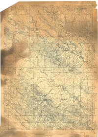
1905 Map of Indian
USGS Topo · Published 1905About this map
The ranching landscape of Butte County during the earliest years of the twentieth century is defined by its sparse, isolated outposts connected by primitive trails. Surveyed by Chester Irvine and S.P. Floore under the direction of E.M. Douglas, this topography reveals a high-plains environment where water sources dictated human settlement. Notable waypoints like Indian Road Ranch, Grant's Road Ranch, and O'Connor's Ranch serve as primary landmarks across a terrain carved by Bull Creek and Fly Creek. The map provides a rare look at the original placement of these frontier ranches before modern development, marking topographical features such as Antelope Butte and the distinctive Mud Buttes. Waterways like Prairie Dog Creek and Middle Creek cut through the landscape, illustrating the critical relationship between the drainage network and the homesteading patterns of the era.
Find a feature on this map
12 named features on this map. Tap any name to fly to it.
Don’t see what you’re looking for? This feature index may not catch every label — zoom into the map to look around manually.
Map Details
Editions of this 1905 Indian Map
This is the sole edition of this map. No revisions or reprints were ever made.
Other maps of this area

1901 · Aladdin
USGS Topo · 1:125,000

1903 · Aladdin
USGS Topo · 1:125,000

1905 · Saint Onge
USGS Topo · 1:62,500

1906 · Two Top
USGS Topo · 1:62,500

1907 · Belle Fourche
USGS Topo · 1:125,000
1907 · Redwater
USGS Topo · 1:62,500

1935 · Harding
USGS Topo · 1:125,000

1953 · Rapid City
USGS Topo · 1:250,000

1954 · The Forks
USGS Topo · 1:24,000
1954 · Belle Fourche
USGS Topo · 1:24,000