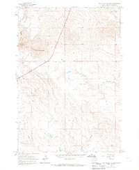
1965 Map of Two Top Butte East
USGS Topo · Published 1967About this map
Two Top Peak and the prominent landform of Two Top Butte dominate this section of the South Dakota landscape, providing a clear view of the drainage patterns in the northern plains. This mid-1960s survey focuses on the intricate networks of Horse Creek and Willow Creek, which carve through the terrain as they flow generally eastward. The map is notable for its inclusion of fine red dashed lines that indicate visible fence and field lines from 1963 aerial photography, a detail of significant value for property history and land-use studies. These markings, alongside the sparse development of township lines like T. 12 N. and T. 11 N., illustrate a rural landscape defined primarily by ranching and natural topography rather than dense settlement.
Find a feature on this map
5 named features on this map. Tap any name to fly to it.
Don’t see what you’re looking for? This feature index may not catch every label — zoom into the map to look around manually.
Map Details
Editions of this 1965 Two Top Butte East Map
This is the sole edition of this map. No revisions or reprints were ever made.
Other maps of this area

1906 · Two Top
USGS Topo · 1:62,500

1907 · Belle Fourche
USGS Topo · 1:125,000

1913 · Newell
USGS Topo · 1:125,000

1935 · Hoover
USGS Topo · 1:125,000

1935 · Harding
USGS Topo · 1:125,000

1953 · Rapid City
USGS Topo · 1:250,000

1954 · Lemmon
USGS Topo · 1:250,000

1957 · Lemmon
USGS Topo · 1:250,000

1957 · Rapid City
USGS Topo · 1:250,000
1965 · Two Top Butte West
USGS Topo · 1:24,000