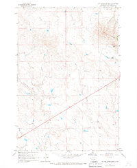
1965 Map of Two Top Butte West
USGS Topo · Published 1967About this map
Two Top Butte serves as the dominant landmark of this prairie landscape in northern Butte County, a region characterized by drainage networks and isolated ranching operations. The topography is defined by the winding paths of Hilderbrand Creek and Horse Creek, which cut through the high plains toward the east and west. Human presence is sparse, centered on the Kinghorn Two Top Ranch situated near the base of the prominent butte. This mid-1960s survey captures the area just as modern infrastructure like Highway 85 began to slice diagonally across the sections, providing a primary transit corridor through the open range. The map illustrates a transitional period for the South Dakota ranching economy, where vast grazing lands were mapped with high-precision photogrammetric methods to document fence lines and small stock ponds.
Find a feature on this map
5 named features on this map. Tap any name to fly to it.
Don’t see what you’re looking for? This feature index may not catch every label — zoom into the map to look around manually.
Map Details
Editions of this 1965 Two Top Butte West Map
This is the sole edition of this map. No revisions or reprints were ever made.
Other maps of this area

1905 · Indian
USGS Topo · 1:62,500

1906 · Two Top
USGS Topo · 1:62,500

1907 · Belle Fourche
USGS Topo · 1:125,000

1935 · Harding
USGS Topo · 1:125,000

1953 · Rapid City
USGS Topo · 1:250,000

1954 · Lemmon
USGS Topo · 1:250,000

1957 · Lemmon
USGS Topo · 1:250,000

1957 · Rapid City
USGS Topo · 1:250,000
1965 · Antelope Butte
USGS Topo · 1:24,000
1965 · Two Top Butte East
USGS Topo · 1:24,000