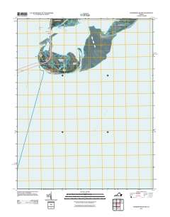
2011 Map of Fishermans Island
USGS Topo · Published 2011About this map
Cape Charles and the southern tip of the Delmarva Peninsula meet the confluence of the Atlantic Ocean and Chesapeake Bay in this coastal survey. The landscape is defined by its maritime navigation and infrastructure, anchored by the Cape Charles Lighthouse on Smith Island and the Fishermans Island Light positioned to the west. This area serves as a critical transition for travelers and maritime traffic, featuring the Fishermans Inlet Bridge which spans the waters near Wise Point. The map details the shifting landforms of the barrier islands, including the marshy reaches of Fishermans Island, Adams Island, and the small coastal feature known as The Isaacs. This geography illustrates the intricate relationship between the protected waters of Magothy Bay and the open North Channel, providing an essential view of the Virginia coastline’s modern environmental and navigational state.
Find a feature on this map
14 named features on this map. Tap any name to fly to it.
Don’t see what you’re looking for? This feature index may not catch every label — zoom into the map to look around manually.
Map Details
Editions of this 2011 Fishermans Island Map
This is the sole edition of this map. No revisions or reprints were ever made.
Other maps of this area

1893 · Virginia Beach
USGS Topo · 1:125,000

1907 · Norfolk
USGS Topo · 1:125,000

1918 · Cape Henry
USGS Topo · 1:62,500

1919 · Cape Henry
USGS Topo · 1:62,500

1943 · Elliots Creek
USGS Topo · 1:25,000

1943 · Townsend
USGS Topo · 1:24,000

1943 · Richmond
USGS Topo · 1:250,000

1946 · Eastville
USGS Topo · 1:250,000

1946 · Currituck Sound
USGS Topo · 1:250,000

1949 · Richmond
USGS Topo · 1:250,000