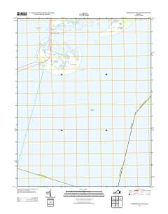
2013 Map of Fishermans Island
USGS Topo · Published 2013About this map
Fishermans Island and its surrounding archipelago dominate this coastal survey at the southern tip of the Delmarva Peninsula. The landscape is defined by the vital transportation corridor of the Lankford Hwy, which traverses the marshes via the Fishermans Inlet Bridge to connect the Eastern Shore with the Virginia mainland across the Chesapeake Bay. This 2013 snapshot records the critical maritime infrastructure of the region, including the Cape Charles Lighthouse on Smith Island and the Fishermans Island Light, both essential for navigating the complex waters of the Smith Island Inlet. To the east, the barrier island chain continues with Adams Island and the marshy outcrops known as The Isaacs, while the treacherous Nautilus Shoal lies submerged in the Atlantic Ocean, illustrating the dynamic and shifting nature of Virginia's coastal geography.
Find a feature on this map
19 named features on this map. Tap any name to fly to it.
Don’t see what you’re looking for? This feature index may not catch every label — zoom into the map to look around manually.
Map Details
Editions of this 2013 Fishermans Island Map
This is the sole edition of this map. No revisions or reprints were ever made.
Other maps of this area

1893 · Virginia Beach
USGS Topo · 1:125,000

1907 · Norfolk
USGS Topo · 1:125,000

1918 · Cape Henry
USGS Topo · 1:62,500

1919 · Cape Henry
USGS Topo · 1:62,500

1943 · Elliots Creek
USGS Topo · 1:25,000

1943 · Townsend
USGS Topo · 1:24,000

1943 · Richmond
USGS Topo · 1:250,000

1946 · Eastville
USGS Topo · 1:250,000

1946 · Currituck Sound
USGS Topo · 1:250,000

1949 · Richmond
USGS Topo · 1:250,000