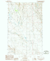
1986 Map of Fivemile Coulee East
USGS Topo · Published 1986About this map
Powers Creek and Simmons Creek weave through this section of Toole County, carving a landscape defined by intermittent watercourses and topographic variation. Surveyed in the mid-1980s, the map reveals a remote ranching or agricultural environment where movement is dictated by the deeply etched coulees typical of northern Montana. Significant drainage systems such as Fivemile Coulee and Miners Coulee dominate the eastern and southern portions of the sheet, illustrating how water has historically shaped the local terrain.
Find a feature on this map
10 named features on this map. Tap any name to fly to it.
Don’t see what you’re looking for? This feature index may not catch every label — zoom into the map to look around manually.
Map Details
Editions of this 1986 Fivemile Coulee East Map
This is the sole edition of this map. No revisions or reprints were ever made.
Other maps of this area

1943 · Antelope Coulee
USGS Topo · 1:62,500

1945 · West Butte
USGS Topo · 1:62,500

1954 · Shelby
USGS Topo · 1:250,000

1958 · Shelby
USGS Topo · 1:250,000

1962 · Cameron Lake
USGS Topo · 1:24,000

1962 · Hawthorne School
USGS Topo · 1:24,000

1962 · Fey Lakes
USGS Topo · 1:24,000

1984 · Sweet Grass Hills
USGS Topo · 1:100,000
1986 · Antelope Coulee NW
USGS Topo · 1:24,000
1986 · Johannson Coulee
USGS Topo · 1:24,000