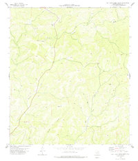
1978 Map of Flat Rock Creek North
USGS Topo · Published 1978About this map
Sycamore Creek and Flat Rock Creek dominate this Edwards County landscape, carving through the limestone terrain of the Texas Hill Country. The 1970s survey illustrates a ranching and resource-extraction economy, marked by several Gravel Pits and isolated settlements like Hayes and Maurice. Water security is a central theme of the map, evidenced by the numerous marked sources including New Well, High Well, and a Drill Hole. The subterranean character of the region is highlighted by features such as Midnight Cave and Indian Gap, reflecting the karst topography common to this part of the state. A network of Jeep Trails provides the primary access to Maurice Canyon, showing how the local population navigated the steep elevation changes and winding drainage patterns long before modern infrastructure reached these interior rangelands.
Find a feature on this map
16 named features on this map. Tap any name to fly to it.
Don’t see what you’re looking for? This feature index may not catch every label — zoom into the map to look around manually.
Map Details
Editions of this 1978 Flat Rock Creek North Map
This is the sole edition of this map. No revisions or reprints were ever made.
Other maps of this area

1893 · Nueces
USGS Topo · 1:125,000

1896 · Nueces
USGS Topo · 1:125,000

1943 · Carta Valley
USGS Topo · 1:62,500

1944 · Flat Rock
USGS Topo · 1:62,500

1944 · Indian Creek
USGS Topo · 1:62,500

1944 · Indian Mountain
USGS Topo · 1:62,500

1958 · Del Rio
USGS Topo · 1:250,000

1964 · Del Rio
USGS Topo · 1:250,000
1974 · Twomile Draw
USGS Topo · 1:24,000
1974 · Kickapoo Caverns
USGS Topo · 1:24,000