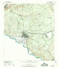
1958 Map of Del Rio
USGS Topo · Published 1970About this map
The vast Amistad Reservoir dominates the center of this landscape, where the Rio Grande, Devils River, and Pecos River converge along the international boundary. This era captures the region's ranching and military character, anchored by the expansion of Laughlin AFB near Del Rio and the strategic route of the Southern Pacific railroad. Smaller rail-stop settlements like Pumpville, Shumla, and Malvado dot the western reaches, while the eastern section features the more established centers of Brackettville and Spofford. The terrain transitions from the deep incisions of Deadmans Canyon in the west to a cluster of named peaks in the east, including Las Moras Mountain, Turkey Mountain, and Asphalt Mountain. The map also details numerous unnamed ranch sites and the network of state highways, including Highway 277 and Highway 377, that connected these remote South Texas outposts during the late 1950s.
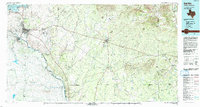
Find a feature on this map
43 named features on this map. Tap any name to fly to it.
Don’t see what you’re looking for? This feature index may not catch every label — zoom into the map to look around manually.
Map Details
Editions of this 1958 Del Rio Map
2 editions found
Historical Maps of Brackettville Through Time
4 maps found