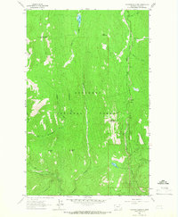
1963 Map of Flatiron Mountain
USGS Topo · Published 1966About this map
Kootenai National Forest dominates this 1963 survey of the Lincoln County high country, where drainage patterns define the remote landscape. The summit of Flatiron Mountain stands as a central landmark between the deep drainage of Flattail Creek and the headwaters of Pipe Creek. To the west, the terrain rises sharply toward Sheepherder Mountain and Indian Peak, while to the north, the isolated Lake Rene feeds into Clay Creek. The map documents a transition in local hydrology, showing the South Fork Yaak River as it receives tributaries like Smoot Creek and Zulu Creek. Unlike more settled regions, the primary indicators of human presence here are the unimproved dirt roads and light-duty tracks that follow the natural contours of the mountain passes, providing a clear record of 1960s forest access before modern developments altered these backcountry routes.
Find a feature on this map
22 named features on this map. Tap any name to fly to it.
Don’t see what you’re looking for? This feature index may not catch every label — zoom into the map to look around manually.
Map Details
Editions of this 1963 Flatiron Mountain Map
This is the sole edition of this map. No revisions or reprints were ever made.
Other maps of this area

1957 · Kalispell
USGS Topo · 1:250,000

1960 · Kalispell
USGS Topo · 1:250,000

1961 · Kalispell
USGS Topo · 1:250,000

1963 · Yaak
USGS Topo · 1:24,000

1963 · Turner Mountain
USGS Topo · 1:24,000

1963 · Sylvanite
USGS Topo · 1:24,000

1963 · Pulpit Mountain
USGS Topo · 1:24,000

1963 · Pink Mountain
USGS Topo · 1:24,000

1963 · Clark Mountain
USGS Topo · 1:24,000

1963 · Lost Horse Mountain
USGS Topo · 1:24,000