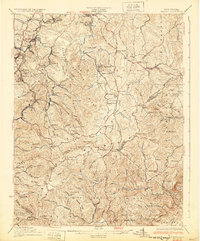
1932 Map of Flattop
USGS Topo · Published 1932About this map
Shady Spring Mountain and the Whiteoak Mountain ridge dominate this Southern West Virginia landscape during the early 1930s. The coal and timber economies are evident in the dense network of small company towns and loading points like Besoco, Pickshin, and Lillybrook along the Virginian RR. While the western portion of the map is defined by industrial activity and the winding waters of Winding Gulf, the eastern sections transition into more traditional rural settlements.
Find a feature on this map
110 named features on this map. Tap any name to fly to it.
Don’t see what you’re looking for? This feature index may not catch every label — zoom into the map to look around manually.
Map Details
Editions of this 1932 Flattop Map
2 editions found
Other maps of this area

1887 · Pocahontas
USGS Topo · 1:125,000

1887 · Hinton
USGS Topo · 1:125,000

1890 · Dublin
USGS Topo · 1:125,000

1891 · Pocahontas
USGS Topo · 1:125,000

1891 · Dublin
USGS Topo · 1:125,000

1891 · Raleigh
USGS Topo · 1:125,000

1892 · Hinton
USGS Topo · 1:125,000

1894 · Pocahontas
USGS Topo · 1:125,000

1895 · Pocahontas
USGS Topo · 1:125,000

1897 · Raleigh
USGS Topo · 1:125,000