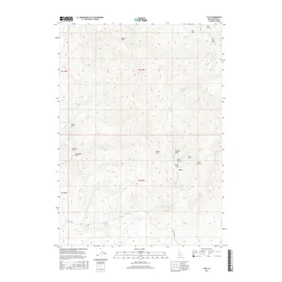
2017 Map of Flint
USGS Topo · Published 2017About this map
Flint anchors this high-elevation terrain in Owyhee County, positioned amidst a network of drainage systems and summits of the Silver City Range. The settlement is surrounded by a dense concentration of deep ravines, including Mine Gulch, Astor Gulch, and Twilight Gulch, suggesting a legacy of resource extraction and prospecting. The landscape is carved by numerous watercourses such as Jordan Cr, Buck Cr, and Little Sawmill Cr, which navigate the steep contours between peaks like Dewey Peak and the landmark known as Black Warrior. Access to this remote region is defined by the winding paths of Flint Rd and Flint Creek Rd, which follow the natural topography of the gulches. Water sources like De Lamar Spring and Barrel Spring provide critical points of interest in a territory otherwise defined by its sharp vertical relief and seasonal creek beds.
Find a feature on this map
30 named features on this map. Tap any name to fly to it.
Don’t see what you’re looking for? This feature index may not catch every label — zoom into the map to look around manually.
Map Details
Editions of this 2017 Flint Map
This is the sole edition of this map. No revisions or reprints were ever made.
Other maps of this area

1892 · Silver City
USGS Topo · 1:125,000

1894 · Silver City
USGS Topo · 1:125,000

1898 · Silver City
USGS Topo · 1:125,000

1955 · Jordan Valley
USGS Topo · 1:250,000

1955 · Boise
USGS Topo · 1:250,000

1957 · Jordan Valley
USGS Topo · 1:250,000

1958 · Boise
USGS Topo · 1:250,000

1958 · Jordan Valley
USGS Topo · 1:250,000

1962 · Boise
USGS Topo · 1:250,000

1965 · Triangle
USGS Topo · 1:62,500