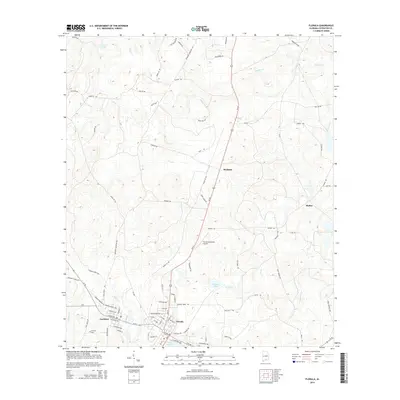
2014 Map of Florala
USGS Topo · Published 2014About this map
Lake Jackson sits at the heart of this Southern Alabama landscape, anchoring the border-straddling community of Florala. The town’s structured grid contrasts with the surrounding Covington County countryside, which is defined by a dense network of watercourses and minor ponds like Thomas Pond and Lawrence Pond. To the west, the settlement of Lockhart is prominently featured alongside the Lockhart Cem, illustrating the local development pattern of clustered townships separated by timberlands and creek drainages. The area's infrastructure is marked by the Florala Municipal Airport and a web of rural roads such as Shoe Spring Rd and Tram Loop, which hint at the region's historical reliance on forestry and local transit. Tributaries like Panther Cr and Moccasin Br carve through the terrain, showing the natural drainage patterns that have historically shaped land use and property boundaries in this part of the state.
Find a feature on this map
86 named features on this map. Tap any name to fly to it.
Don’t see what you’re looking for? This feature index may not catch every label — zoom into the map to look around manually.
Map Details
Editions of this 2014 Florala Map
This is the sole edition of this map. No revisions or reprints were ever made.
Other maps of this area

1949 · Glendale
USGS Topo · 1:62,500

1949 · Laurel Hill
USGS Topo · 1:62,500

1950 · Laurel Hill
USGS Topo · 1:62,500

1951 · Glendale
USGS Topo · 1:62,500

1953 · Andalusia
USGS Topo · 1:250,000

1957 · Andalusia
USGS Topo · 1:250,000

1957 · Pensacola
USGS Topo · 1:250,000

1959 · Pensacola
USGS Topo · 1:250,000

1960 · Pensacola
USGS Topo · 1:250,000
1969 · Hacoda
USGS Topo · 1:24,000