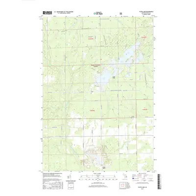
2017 Map of Floyd Lake
USGS Topo · Published 2017About this map
The Huron National Forest dominates this section of Iosco County, where a dense network of glacial lakes and tributaries defines the landscape. The geography is characterized by clusters of water bodies including Floyd Lake, Sand Lake, and Indian Lake, which are interconnected by small creeks like Smith Cr and Vaughn Cr. Settlement is sparse, represented by the small community of White Rock in the southern portion of the map.
Find a feature on this map
71 named features on this map. Tap any name to fly to it.
Don’t see what you’re looking for? This feature index may not catch every label — zoom into the map to look around manually.
Map Details
Editions of this 2017 Floyd Lake Map
This is the sole edition of this map. No revisions or reprints were ever made.
Other maps of this area

1954 · Tawas City
USGS Topo · 1:250,000

1958 · Tawas City
USGS Topo · 1:250,000

1959 · Tawas City
USGS Topo · 1:62,500

1966 · Alabaster
USGS Topo · 1:24,000

1966 · National City
USGS Topo · 1:24,000

1968 · Hale
USGS Topo · 1:24,000

1968 · Whittemore
USGS Topo · 1:24,000

1968 · Hale SE
USGS Topo · 1:24,000

1984 · Tawas City
USGS Topo · 1:100,000
1989 · Sid Town
USGS Topo · 1:24,000