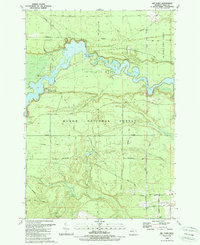
1989 Map of Sid Town
USGS Topo · Published 1989About this map
The Au Sable River corridor defines this landscape in eastern Michigan, where the waters are harnessed for hydroelectric power at the Cooke Powerplant. This 1989 edition shows the wide expanse of Cooke Pond created by the dam, providing a central recreational hub surrounded by the Au Sable State Forest and Huron National Forest. The settlement of Sid Town is situated on the southern bank of the reservoir, while further south, the Wilber Ch stands as a local landmark near the Iosco County boundary.
Find a feature on this map
36 named features on this map. Tap any name to fly to it.
Don’t see what you’re looking for? This feature index may not catch every label — zoom into the map to look around manually.
Map Details
Editions of this 1989 Sid Town Map
This is the sole edition of this map. No revisions or reprints were ever made.
Other maps of this area

1954 · Tawas City
USGS Topo · 1:250,000

1958 · Tawas City
USGS Topo · 1:250,000

1959 · Tawas City
USGS Topo · 1:62,500

1959 · East Tawas
USGS Topo · 1:62,500

1959 · Glennie
USGS Topo · 1:62,500

1959 · Harrisville
USGS Topo · 1:62,500

1983 · Hubbard Lake
USGS Topo · 1:100,000

1984 · Tawas City
USGS Topo · 1:100,000

1989 · Mikado
USGS Topo · 1:24,000
1989 · Glennie
USGS Topo · 1:24,000