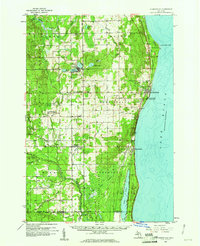
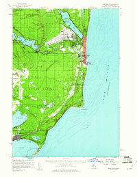
1959 Map of Harrisville
USGS Topo · Published 1961About this map
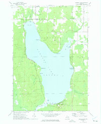
The shore of Lake Huron and the inland timberlands of Alcona County define this late-1950s landscape, anchored by the coastal settlement of Harrisville. Along the lakefront, the Detroit and Mackinac Railroad and the Mackinac Trail run parallel to the coast, passing through Harrisville State Park and the historic lighthouse at Sturgeon Point. Moving inland, the terrain transitions into the managed forests of the Huron National Forest and Alcona State Forest. Small farming and timber communities like Lincoln, Mikado, and Killmaster are scattered across the interior, connected by a network of creeks and branches including the East Branch Pine River and Sucker Creek. Local social centers such as the Grange Hall in Haynes and the Indian Mission near Oscoda Hill reflect the era's rural community life, while numerous gravel pits indicate the local reliance on extractive resources during this period of development.
Find a feature on this map
55 named features on this map. Tap any name to fly to it.
Don’t see what you’re looking for? This feature index may not catch every label — zoom into the map to look around manually.
Map Details
Editions of this 1959 Harrisville Map
3 editions found
Other maps of this area

1954 · Tawas City
USGS Topo · 1:250,000

1958 · Tawas City
USGS Topo · 1:250,000
1959 · Tawas City
USGS Topo · 1:62,500
1959 · East Tawas
USGS Topo · 1:62,500
1959 · Glennie
USGS Topo · 1:62,500
1971 · Spruce
USGS Topo · 1:24,000
1971 · Black River
USGS Topo · 1:24,000
1972 · Hubbard Lake
USGS Topo · 1:24,000

1983 · Hubbard Lake
USGS Topo · 1:100,000

1984 · Tawas City
USGS Topo · 1:100,000
Featured Places
- Greenbush, Greenbush Township
- Mikado, Mikado Township
- Gustin, Gustin Township
- Harrisville, MI
- Lincoln, MI