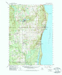
1959 Map of Harrisville
USGS Topo · Published 1987About this map
Lake Huron defines the eastern edge of this late-1950s landscape, where the Detroit and Mackinac railroad connects shoreline communities like Harrisville and Greenbush. The interior reveals a transition from the structured street grids of Lincoln to the dense woodlands of the Huron National Forest and Alcona State Forest. This survey captures Alcona County's mid-century civic and social infrastructure, from the Alcona High Sch and Town Hall to local hubs like the Grange Hall.
Find a feature on this map
58 named features on this map. Tap any name to fly to it.
Don’t see what you’re looking for? This feature index may not catch every label — zoom into the map to look around manually.
Map Details
Editions of this 1959 Harrisville Map
3 editions found
Other maps of this area

1954 · Tawas City
USGS Topo · 1:250,000

1958 · Tawas City
USGS Topo · 1:250,000

1959 · Tawas City
USGS Topo · 1:62,500

1959 · East Tawas
USGS Topo · 1:62,500

1959 · Glennie
USGS Topo · 1:62,500

1959 · Harrisville
USGS Topo · 1:62,500

1971 · Spruce
USGS Topo · 1:24,000
1971 · Black River
USGS Topo · 1:24,000

1972 · Hubbard Lake
USGS Topo · 1:24,000

1983 · Hubbard Lake
USGS Topo · 1:100,000