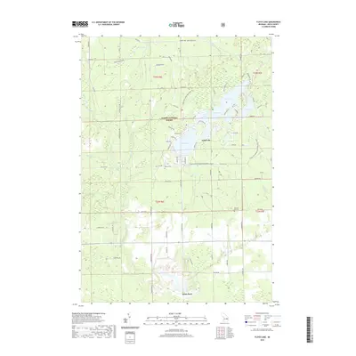
2019 Map of Floyd Lake
USGS Topo · Published 2019About this map
Huron National Forest dominates this section of Iosco County, where a dense network of forest roads and ORV trails connects a cluster of glacial lakes. In the center of the map, Sand Lake serves as a primary landmark, surrounded by secondary waters like Round Lake, Little Island Lake, and Chappell Lake. The drainage of the area is defined by numerous small creeks, including Vaughn Cr, Sand Cr, and Manary Cr, which feed into the East Branch Au Gres River at the southern margin.
Find a feature on this map
79 named features on this map. Tap any name to fly to it.
Don’t see what you’re looking for? This feature index may not catch every label — zoom into the map to look around manually.
Map Details
Editions of this 2019 Floyd Lake Map
This is the sole edition of this map. No revisions or reprints were ever made.
Other maps of this area

1954 · Tawas City
USGS Topo · 1:250,000

1958 · Tawas City
USGS Topo · 1:250,000

1959 · Tawas City
USGS Topo · 1:62,500

1966 · Alabaster
USGS Topo · 1:24,000

1966 · National City
USGS Topo · 1:24,000

1968 · Hale
USGS Topo · 1:24,000

1968 · Whittemore
USGS Topo · 1:24,000

1968 · Hale SE
USGS Topo · 1:24,000

1984 · Tawas City
USGS Topo · 1:100,000
1989 · Sid Town
USGS Topo · 1:24,000