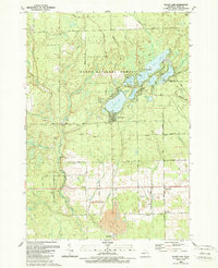
1989 Map of Floyd Lake
USGS Topo · Published 1989About this map
Huron National Forest dominates this landscape in eastern Michigan, where the high concentration of kettle lakes and meandering watercourses defines the local topography. The settlement of Sand Lake serves as a central point for outdoor recreation, situated among a dense cluster of water bodies including Floyd Lake, Indian Lake, and Round Lake. To the south, the terrain transitions into industrial and agricultural use near the small community of Hemlock, where the Au Gres River cuts through the township.
Find a feature on this map
55 named features on this map. Tap any name to fly to it.
Don’t see what you’re looking for? This feature index may not catch every label — zoom into the map to look around manually.
Map Details
Editions of this 1989 Floyd Lake Map
This is the sole edition of this map. No revisions or reprints were ever made.
Other maps of this area

1954 · Tawas City
USGS Topo · 1:250,000

1958 · Tawas City
USGS Topo · 1:250,000

1959 · Tawas City
USGS Topo · 1:62,500

1966 · Alabaster
USGS Topo · 1:24,000

1966 · National City
USGS Topo · 1:24,000

1968 · Hale
USGS Topo · 1:24,000

1968 · Whittemore
USGS Topo · 1:24,000

1968 · Hale SE
USGS Topo · 1:24,000

1984 · Tawas City
USGS Topo · 1:100,000
1989 · Sid Town
USGS Topo · 1:24,000