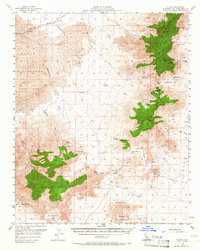
1956 Map of Flynn
USGS Topo · Published 1966About this map
The Providence Mountains and the Granite Mountains dominate this Mojave Desert landscape, sheltering a network of vital water sources and mineral claims. In a region where water dictated survival, the map records numerous named points including Snake Spring, Cornfield Spring, and Budweiser Spring. These springs supported early ranching and mining operations, such as the Pine Tree Ranch and the Vulcan Mine. The Union Pacific railroad cuts through the northern sector near the settlement of Flynn, following the natural corridor of the Winston Wash.
Find a feature on this map
50 named features on this map. Tap any name to fly to it.
Don’t see what you’re looking for? This feature index may not catch every label — zoom into the map to look around manually.
Map Details
Editions of this 1956 Flynn Map
3 editions found

Other maps of this area

1910 · Ivanpah
USGS Topo · 1:250,000

1912 · Ivanpah
USGS Topo · 1:250,000

1942 · Ivanpah
USGS Topo · 1:250,000

1942 · Amboy
USGS Topo · 1:250,000

1943 · Amboy
USGS Topo · 1:250,000

1943 · Danby
USGS Topo · 1:62,500

1947 · Kingman
USGS Topo · 1:250,000

1948 · Kingman
USGS Topo · 1:250,000

1954 · Needles
USGS Topo · 1:250,000

1954 · Kingman
USGS Topo · 1:250,000