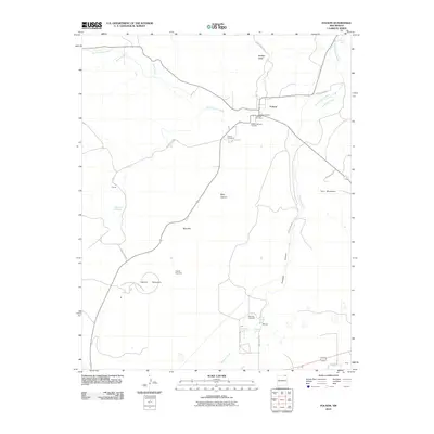
2010 Map of Folsom
USGS Topo · Published 2010About this map
Folsom sits at the junction of several county roads in Union County, serving as a central point for the surrounding volcanic landscape. The settlement's connection to transportation history is visible in the Folsom Railroad Tank Bed, while the local Folsom Post Office marks the village's continued presence. The geography is defined by prominent peaks and watercourses, including Capulin Mountain and Twin Mountain, which rise above the Dry Cimarron River and the winding Pinabete Creek. Smaller family and community sites like Ellis and Cornay are scattered throughout the quadrangle, alongside several burial grounds such as Draw Cemetery and Martinez Cemetery. This area reflects the dispersed ranching and transit patterns of Northeastern New Mexico, where deep canyons like Pinabete Canyon provide natural pathways through the high plains.
Find a feature on this map
32 named features on this map. Tap any name to fly to it.
Don’t see what you’re looking for? This feature index may not catch every label — zoom into the map to look around manually.
Map Details
Editions of this 2010 Folsom Map
This is the sole edition of this map. No revisions or reprints were ever made.
Other maps of this area

1954 · Raton
USGS Topo · 1:250,000

1954 · Dalhart
USGS Topo · 1:250,000

1958 · Raton
USGS Topo · 1:250,000

1958 · Dalhart
USGS Topo · 1:250,000

1962 · Dalhart
USGS Topo · 1:250,000
1971 · Trinchera Pass
USGS Topo · 1:24,000

1971 · Kiowa
USGS Topo · 1:24,000

1971 · Robinson Peak
USGS Topo · 1:24,000

1972 · Emery Peak
USGS Topo · 1:24,000

1972 · Little Grande
USGS Topo · 1:24,000