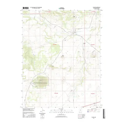
2017 Map of Folsom
USGS Topo · Published 2017About this map
Capulin Volcano National Monument dominates the southwestern portion of this landscape, showcasing the distinct volcanic geology of northeastern New Mexico. The conical form of Capulin Mtn and the surrounding Lava Flow define the terrain, while nearby features like Baby Capulin, Mud Hill, and Twin Mtn illustrate a broader field of volcanic activity. To the northeast, the settlement of Folsom sits near the banks of the Dry Cimarron River, serving as a focal point for the region’s sparse road network, including Main ST and Dodge ST. The map is particularly useful for genealogical research, identifying local burial sites such as Folsom Cem, Drew Cem, and Martinez Cem. Natural water sources like Pinabete Springs, Bennett Spring, and Stuyvesant Springs dot the high plains, indicating the vital importance of groundwater in this arid environment cut by deep drainages like Pinabete Canyon.
Find a feature on this map
40 named features on this map. Tap any name to fly to it.
Don’t see what you’re looking for? This feature index may not catch every label — zoom into the map to look around manually.
Map Details
Editions of this 2017 Folsom Map
This is the sole edition of this map. No revisions or reprints were ever made.
Other maps of this area

1954 · Raton
USGS Topo · 1:250,000

1954 · Dalhart
USGS Topo · 1:250,000

1958 · Raton
USGS Topo · 1:250,000

1958 · Dalhart
USGS Topo · 1:250,000

1962 · Dalhart
USGS Topo · 1:250,000
1971 · Trinchera Pass
USGS Topo · 1:24,000

1971 · Kiowa
USGS Topo · 1:24,000

1971 · Robinson Peak
USGS Topo · 1:24,000

1972 · Emery Peak
USGS Topo · 1:24,000

1972 · Little Grande
USGS Topo · 1:24,000