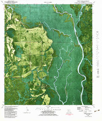
1982 Map of Forbes Island
USGS Topo · Published 1984About this map
The Apalachicola River defines the landscape of this riverine corridor, where it serves as a boundary between Gulf, Liberty, and Franklin counties. This 1982 orthophotomap provides a rare look at the dense riparian environment of Forbes Island and the Apalachicola National Forest before modern developments. The map highlights the area's river-dependent history through numerous water access points such as Brickyard Landing, Smith Creek Landing, and Von Horn Landing. Cultural and historical markers are concentrated along the eastern banks, most notably the Fort Gadsden State Historic Site and the Hickory Landing Campground. To the west, the small settlement of Howard Creek and more isolated locations like Lister Camp and Kenny Camp represent the area's tucked-away fishing and timber camps. Local infrastructure is reflected by Willis Landing Road and a scattering of sandpits throughout the Indian Swamp region.
Find a feature on this map
43 named features on this map. Tap any name to fly to it.
Don’t see what you’re looking for? This feature index may not catch every label — zoom into the map to look around manually.
Map Details
Editions of this 1982 Forbes Island Map
This is the sole edition of this map. No revisions or reprints were ever made.
Other maps of this area

1943 · Jackson River
USGS Topo · 1:24,000

1944 · White City
USGS Topo · 1:24,000

1944 · Forbes Island
USGS Topo · 1:24,000

1945 · Forbes Island
USGS Topo · 1:31,680

1945 · Lake Wimico
USGS Topo · 1:31,680

1945 · Kennedy Creek
USGS Topo · 1:31,680

1945 · White City
USGS Topo · 1:31,680

1945 · Beverly
USGS Topo · 1:31,680

1945 · Wewahitchka
USGS Topo · 1:31,680

1945 · Jackson River
USGS Topo · 1:31,680