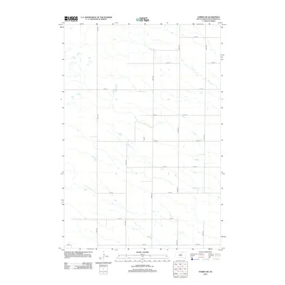
2012 Map of Forbes SW
USGS Topo · Published 2012About this map
Willow Cr meanders across this rural expanse of McPherson County, defining the drainage patterns of a landscape carved by subtle prairie depressions. The section-line road grid, a hallmark of the Great Plains, is established here by corridors such as 361st Ave and 364th Ave, which intersect with east-west routes like 105th St and 113th St. This 2012 survey illustrates the enduring agricultural structure of the region, where large parcels of land are partitioned by a systematic network including Ash Pl and 363rd Ave. Small wetlands and seasonal water bodies are scattered throughout the quadrangle, reflecting the glacial topography typical of the South Dakota plains. The absence of dense town sites highlights the area's character as a sparsely populated farming and ranching territory where local geography is tied primarily to the section lines and the flow of the creek.
Find a feature on this map
16 named features on this map. Tap any name to fly to it.
Don’t see what you’re looking for? This feature index may not catch every label — zoom into the map to look around manually.
Map Details
Editions of this 2012 Forbes SW Map
This is the sole edition of this map. No revisions or reprints were ever made.
Other maps of this area

1899 · Ellendale
USGS Topo · 1:125,000

1954 · Aberdeen
USGS Topo · 1:250,000

1956 · Aberdeen
USGS Topo · 1:250,000

1968 · Long Lake SE
USGS Topo · 1:24,000

1968 · Forbes
USGS Topo · 1:24,000

1968 · Long Lake NE
USGS Topo · 1:24,000

1968 · Forbes SE
USGS Topo · 1:24,000
1968 · Forbes NW
USGS Topo · 1:24,000

1968 · Forbes SW
USGS Topo · 1:24,000

1970 · Leola
USGS Topo · 1:24,000