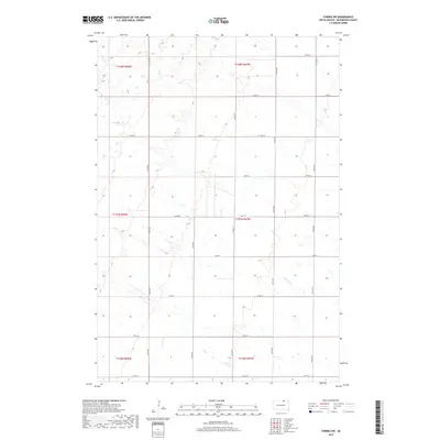
2017 Map of Forbes SW
USGS Topo · Published 2017About this map
Willow Cr meanders through the central and southern sections of this McPherson County landscape, defining the local drainage pattern amidst a structured grid of rural roads. This 2017 survey reflects the high plains' agricultural layout, where primary north-south corridors like 361st Ave and 365th Ave intersect with east-west routes such as 105th St and 113th St. The intersection of Co Hwy 19 and Cty Hwy 8 serves as a focal point for local transit, anchoring the township divisions including t127n r67w and t127n r68w. The map illustrates a meticulously planned rural geography where section lines dictate the placement of farmsteads and field boundaries, while natural hydrology like the scattered wetlands and intermittent creek beds provide the only break in the geometric regularity of the prairie.
Find a feature on this map
25 named features on this map. Tap any name to fly to it.
Don’t see what you’re looking for? This feature index may not catch every label — zoom into the map to look around manually.
Map Details
Editions of this 2017 Forbes SW Map
This is the sole edition of this map. No revisions or reprints were ever made.
Other maps of this area

1899 · Ellendale
USGS Topo · 1:125,000

1954 · Aberdeen
USGS Topo · 1:250,000

1956 · Aberdeen
USGS Topo · 1:250,000

1968 · Long Lake SE
USGS Topo · 1:24,000

1968 · Forbes
USGS Topo · 1:24,000

1968 · Long Lake NE
USGS Topo · 1:24,000

1968 · Forbes SE
USGS Topo · 1:24,000
1968 · Forbes NW
USGS Topo · 1:24,000

1968 · Forbes SW
USGS Topo · 1:24,000

1970 · Leola
USGS Topo · 1:24,000