1941 Map of Ford
USGS Topo · Published 1941About this map
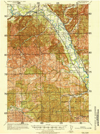
Timber and transport define this portion of the Pacific Northwest as it appeared before the mid-century, where the Chehalis River valley serves as a corridor for both water and rail. The Northern Pacific railroad tracks follow the river's path, connecting the settlements of Saginaw, Malone, and Porter. High above the valley floor, the landscape transitions into the steep slopes of Minot Peak and Blue Mountain, where a legacy of resource extraction is evident in labels for Logging activity and a Logging Camp (Abandoned) tucked near the southern border. Rural life in the early 1940s is anchored by small community centers like Garrard Creek Sch and South Park Sch, which served the families living along Garrard Creek and the surrounding Prairie. This survey captures the region just as wartime demands were intensifying the use of its forest and rail networks.
Find a feature on this map
49 named features on this map. Tap any name to fly to it.
Don’t see what you’re looking for? This feature index may not catch every label — zoom into the map to look around manually.
Map Details
Editions of this 1941 Ford Map
2 editions found
Other maps of this area

1939 · Shelton
USGS Topo · 1:62,500
1940 · Montesano
USGS Topo · 1:62,500

1941 · Walville
USGS Topo · 1:62,500

1941 · Meskill
USGS Topo · 1:62,500

1941 · Mobray
USGS Topo · 1:62,500

1941 · Gate
USGS Topo · 1:62,500

1941 · Ford
USGS Topo · 1:62,500

1943 · Nahwatzel Lake
USGS Topo · 1:62,500

1943 · Mobray
USGS Topo · 1:62,500

1953 · Hoquiam
USGS Topo · 1:250,000