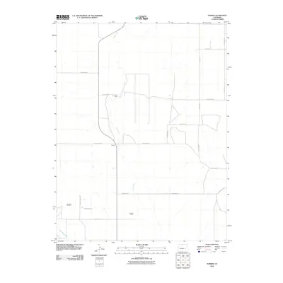
2010 Map of Forder
USGS Topo · Published 2010About this map
Horse Creek and its tributary Little Horse Creek dictate the layout of this section of the Colorado high plains, where water and ranching have long defined the landscape. This 2010 survey shows a sparsely populated area where large-scale operations like the Forder Ranch and Bar WW Ranch are the primary landmarks. The small settlement of Forder sits at the junction of County Road M and the creek, serving as a focal point for the surrounding rural territory. For genealogists, the Spring Hill Cemetery near County Lane 18 provides a vital point of interest in an otherwise open ranching environment. The map's grid-like road system, featuring routes such as County Road R and County RD 23, reflects the late 20th-century development of local transit across Lincoln County's vast pastures.
Find a feature on this map
19 named features on this map. Tap any name to fly to it.
Don’t see what you’re looking for? This feature index may not catch every label — zoom into the map to look around manually.
Map Details
Editions of this 2010 Forder Map
This is the sole edition of this map. No revisions or reprints were ever made.
Other maps of this area

1889 · Sanborn
USGS Topo · 1:125,000

1891 · Sanborn
USGS Topo · 1:125,000

1893 · Sanborn
USGS Topo · 1:125,000

1954 · Lamar
USGS Topo · 1:250,000

1958 · Lamar
USGS Topo · 1:250,000

1975 · Stanley Gulch
USGS Topo · 1:24,000

1977 · Walker Point
USGS Topo · 1:24,000

1977 · Punkin Center
USGS Topo · 1:24,000
1978 · Peace Valley
USGS Topo · 1:24,000
1978 · Metz Springs
USGS Topo · 1:24,000