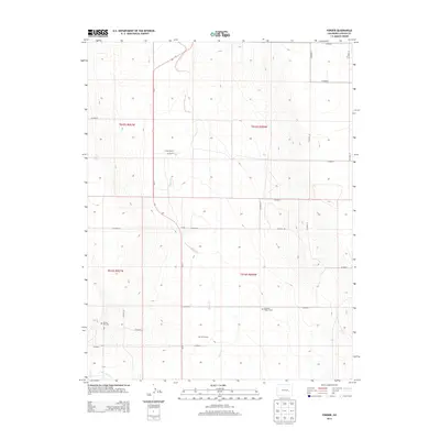
2013 Map of Forder
USGS Topo · Published 2013About this map
Forder and the surrounding rangeland of Lincoln County are defined by a network of rural county roads and the drainage of Horse Cr. This high plains landscape in eastern Colorado preserves evidence of early ranching and family history through isolated landmarks such as the Forder Ranch and Bar W W Ranch. The map reveals important genealogical sites for local history researchers, including the Spring Hill Cem and the specific location of the Grandma Forgey Grave. Transportation through this territory is anchored by the north-south corridor of Co-71, which connects the various ranching outposts. In the southern portion of the quadrangle, Little Horse Cr meanders through the terrain, illustrating the critical role of water sources in this arid environment.
Find a feature on this map
26 named features on this map. Tap any name to fly to it.
Don’t see what you’re looking for? This feature index may not catch every label — zoom into the map to look around manually.
Map Details
Editions of this 2013 Forder Map
This is the sole edition of this map. No revisions or reprints were ever made.
Other maps of this area

1889 · Sanborn
USGS Topo · 1:125,000

1891 · Sanborn
USGS Topo · 1:125,000

1893 · Sanborn
USGS Topo · 1:125,000

1954 · Lamar
USGS Topo · 1:250,000

1958 · Lamar
USGS Topo · 1:250,000

1975 · Stanley Gulch
USGS Topo · 1:24,000

1977 · Walker Point
USGS Topo · 1:24,000

1977 · Punkin Center
USGS Topo · 1:24,000
1978 · Peace Valley
USGS Topo · 1:24,000
1978 · Metz Springs
USGS Topo · 1:24,000