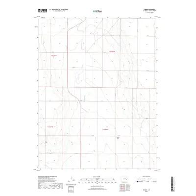
2019 Map of Forder
USGS Topo · Published 2019About this map
Forder sits at the heart of this high plains landscape, defined by a sparse network of county roads and the seasonal drainage of Horse Cr. The region is characterized by large township and range blocks, where the vastness is punctuated by singular, poignant landmarks of human presence. Among these is the Grandma Forgey Grave, a distinct burial site that speaks to the solitary history of the area's homesteading families. To the southwest, the Spring Hill Cem near Little Horse Cr serves as another focal point for genealogical interest. This modern survey by the U.S. Geological Survey captures a landscape of long-standing agricultural boundaries, where the intersection of 71 and various county routes like Co RD N provides the primary structure for this quiet corner of Lincoln County.
Find a feature on this map
22 named features on this map. Tap any name to fly to it.
Don’t see what you’re looking for? This feature index may not catch every label — zoom into the map to look around manually.
Map Details
Editions of this 2019 Forder Map
This is the sole edition of this map. No revisions or reprints were ever made.
Other maps of this area

1889 · Sanborn
USGS Topo · 1:125,000

1891 · Sanborn
USGS Topo · 1:125,000

1893 · Sanborn
USGS Topo · 1:125,000

1954 · Lamar
USGS Topo · 1:250,000

1958 · Lamar
USGS Topo · 1:250,000

1975 · Stanley Gulch
USGS Topo · 1:24,000

1977 · Walker Point
USGS Topo · 1:24,000

1977 · Punkin Center
USGS Topo · 1:24,000
1978 · Peace Valley
USGS Topo · 1:24,000
1978 · Metz Springs
USGS Topo · 1:24,000