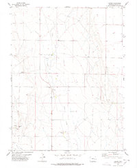
1978 Map of Forder
USGS Topo · Published 1978About this map
Horse Creek flows southward through this High Plains landscape of Lincoln County, defining the drainage patterns for a series of seasonal springs and watering holes. The area is characterized by sparse ranching operations established along the creek bed, most notably at the Forder Ranch and further south at Bar WW Ranch. The small settlement of Forder sits central to these operations, serving as a remote outpost in a region primarily dedicated to cattle grazing. A singular genealogical landmark, Spring Hill Cem, is located in the southwestern quadrant near a Gravel Pit. The map reveals a highly localized infrastructure of water management, with numerous wells and tanks distributed across the sections to support livestock in the arid eastern Colorado terrain. This 1978 documentation captures the enduring rangeland economy of the area before modern shifts in land use.
Find a feature on this map
14 named features on this map. Tap any name to fly to it.
Don’t see what you’re looking for? This feature index may not catch every label — zoom into the map to look around manually.
Map Details
Editions of this 1978 Forder Map
This is the sole edition of this map. No revisions or reprints were ever made.
Other maps of this area

1889 · Sanborn
USGS Topo · 1:125,000

1891 · Sanborn
USGS Topo · 1:125,000

1893 · Sanborn
USGS Topo · 1:125,000

1954 · Lamar
USGS Topo · 1:250,000

1958 · Lamar
USGS Topo · 1:250,000

1975 · Stanley Gulch
USGS Topo · 1:24,000

1977 · Walker Point
USGS Topo · 1:24,000

1977 · Punkin Center
USGS Topo · 1:24,000
1978 · Peace Valley
USGS Topo · 1:24,000
1978 · Metz Springs
USGS Topo · 1:24,000