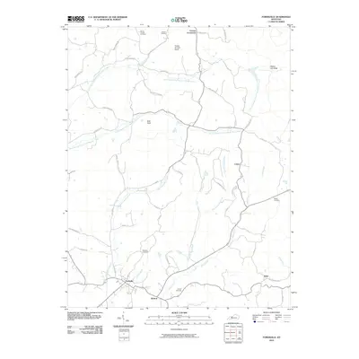
2010 Map of Fordsville
USGS Topo · Published 2010About this map
Fordsville anchors this 2010 topographic record of Ohio County, Kentucky, where the landscape is defined by the branching tributaries of the Adams Fork and the North Branch South Fork Panther Creek. The map provides a high level of detail for genealogists, documenting several family-named burial grounds such as Wedding Cemetery, Haynes Cemetery, and Boling Chapel Cemetery. These sites are linked by a network of rural roads that weave through small settlements like Ellmitch and Victoria Crossroads. Significant terrain features including Turkey Scratch Knob and Bald Knob rise above the stream valleys, illustrating the complex drainage patterns of Line Branch and Dry Branch. To the southeast, the small community of Askin sits near the winding course of Harris Fork, while the northern portion of the quadrangle shows the residential development along Hickory-Lick-Ridge West Rd and Sanders Rd.
Find a feature on this map
54 named features on this map. Tap any name to fly to it.
Don’t see what you’re looking for? This feature index may not catch every label — zoom into the map to look around manually.
Map Details
Editions of this 2010 Fordsville Map
This is the sole edition of this map. No revisions or reprints were ever made.
Other maps of this area

1903 · Tell City
USGS Topo · 1:62,500

1907 · Whitesville
USGS Topo · 1:62,500

1909 · Whitesville
USGS Topo · 1:62,500

1932 · Fordsville
USGS Topo · 1:62,500

1934 · Cannelton
USGS Topo · 1:62,500

1953 · Dundee
USGS Topo · 1:24,000

1953 · Cloverport
USGS Topo · 1:24,000

1953 · Whitesville
USGS Topo · 1:24,000

1953 · Falls Of Rough
USGS Topo · 1:24,000
1953 · Mattingly
USGS Topo · 1:24,000