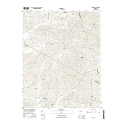
2016 Map of Fordsville
USGS Topo · Published 2016About this map
Fordsville and the surrounding rural communities near the intersection of Ohio, Hancock, and Breckinridge counties are documented here in detail. The settlement pattern is defined by upland ridges and the drainage of Adams Fork and the S Br S Fork Panther Cr. For genealogists, the landscape is dotted with small family and community burial grounds, including Wedding Cem, Sanders Cem, and Haynes Cem near Ellmitch. Distinctive topographic landmarks such as Turkey Scratch Knob and Bald Knob provide clear points of orientation within this dissected plateau. The map also traces an extensive network of local roads like Hawesville Easton Rd and Richardson Rd that connect smaller hamlets like Easton, Cabot, and Victoria Crossroads, illustrating the enduring agricultural and residential layout of this region of Kentucky.
Find a feature on this map
78 named features on this map. Tap any name to fly to it.
Don’t see what you’re looking for? This feature index may not catch every label — zoom into the map to look around manually.
Map Details
Editions of this 2016 Fordsville Map
This is the sole edition of this map. No revisions or reprints were ever made.
Other maps of this area

1903 · Tell City
USGS Topo · 1:62,500

1907 · Whitesville
USGS Topo · 1:62,500

1909 · Whitesville
USGS Topo · 1:62,500

1932 · Fordsville
USGS Topo · 1:62,500

1934 · Cannelton
USGS Topo · 1:62,500

1953 · Dundee
USGS Topo · 1:24,000

1953 · Cloverport
USGS Topo · 1:24,000

1953 · Whitesville
USGS Topo · 1:24,000

1953 · Falls Of Rough
USGS Topo · 1:24,000
1953 · Mattingly
USGS Topo · 1:24,000