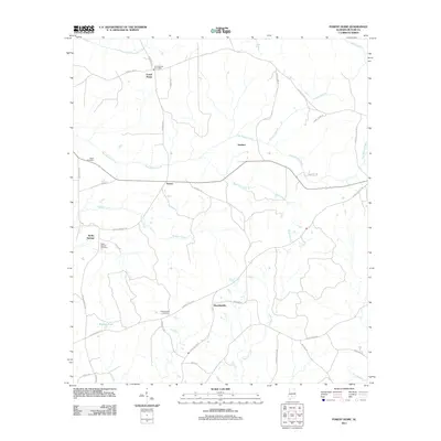
2011 Map of Forest Home
USGS Topo · Published 2011About this map
Forest Home serves as the primary hub of this rural Butler County landscape, marked by its namesake Forest Home Post Office and a network of county roads like County Hwy-46. The terrain is defined by a dense web of waterways, most notably Pine Barren Creek and Panther Creek, which carve through the countryside near small settlements such as Herbert and Saucer. Local heritage is anchored in family and community burial grounds, including Watts Cemetery and the Shacklesville Cemetery near the crossroads of Shacklesville. Further west, Butler Springs appears as a distinct cluster near English Pond, illustrating the typical dispersed settlement pattern of the Alabama coastal plain. The presence of several named branches and branches like Black Branch and Tenmile Branch highlights the intricate drainage system vital to the local topography and land use.
Find a feature on this map
40 named features on this map. Tap any name to fly to it.
Don’t see what you’re looking for? This feature index may not catch every label — zoom into the map to look around manually.
Map Details
Editions of this 2011 Forest Home Map
This is the sole edition of this map. No revisions or reprints were ever made.
Other maps of this area

1953 · Andalusia
USGS Topo · 1:250,000

1957 · Andalusia
USGS Topo · 1:250,000

1971 · Greenville West
USGS Topo · 1:24,000

1971 · Fort Dale
USGS Topo · 1:24,000

1971 · Georgiana East
USGS Topo · 1:24,000

1971 · Bethel
USGS Topo · 1:24,000

1971 · Georgiana West
USGS Topo · 1:24,000

1981 · Pine Apple North
USGS Topo · 1:24,000

1981 · Forest Home
USGS Topo · 1:24,000
1981 · Ridgeville
USGS Topo · 1:24,000