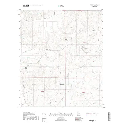
2020 Map of Forest Home
USGS Topo · Published 2020About this map
Forest Home and Butler Springs anchor this portion of Butler County, where a network of rural routes like Monterey Rd and Co Rd 15 weave through a landscape defined by its numerous small waterways. This 2020 map documents a distribution of family and community landmarks, particularly evident in the scattered cemeteries such as Watts Cem and Redicks Cr Cem. These sites, alongside settlements like Saucer and Herbert, indicate a long-standing pattern of dispersed residency tied to the land. The drainage system is particularly dense, with Pine Barren Cr, Redicks Cr, and Long Cr carving through the terrain towards local collection points like English Pond. Researchers can trace the local infrastructure through named connectors like Shakleville Rd and Starlington Rd, which link these small agricultural and residential hubs.
Find a feature on this map
57 named features on this map. Tap any name to fly to it.
Don’t see what you’re looking for? This feature index may not catch every label — zoom into the map to look around manually.
Map Details
Editions of this 2020 Forest Home Map
This is the sole edition of this map. No revisions or reprints were ever made.
Other maps of this area

1953 · Andalusia
USGS Topo · 1:250,000

1957 · Andalusia
USGS Topo · 1:250,000

1971 · Greenville West
USGS Topo · 1:24,000

1971 · Fort Dale
USGS Topo · 1:24,000

1971 · Georgiana East
USGS Topo · 1:24,000

1971 · Bethel
USGS Topo · 1:24,000

1971 · Georgiana West
USGS Topo · 1:24,000

1981 · Pine Apple North
USGS Topo · 1:24,000

1981 · Forest Home
USGS Topo · 1:24,000
1981 · Ridgeville
USGS Topo · 1:24,000