
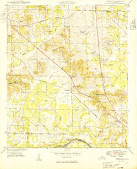
1949 Map of Forkland
USGS Topo · Published 1949About this map
The Tombigbee River defines the southern boundary of this Greene County landscape, where the St Louis San Francisco railroad cuts a diagonal line through the lowlands of Hagan Swamp. The settlement of Forkland serves as a local hub near the river, supported by a network of rural institutions like the Stonewall Taylor Sch and Zion Ch. The map reveals a highly localized social geography, marked by numerous family-named landmarks and small schools such as the Little Zion Sch and Watson Sch. Notable agricultural and residential sites like Meadow Brook Farm and Crestwell Farm are situated among the subtle rises of Burton Hill and Hagan Hill. Along the riverbank, Derder Landing indicates the historical importance of river access even as the railroad and the Six And Three-Quarter Road shifted the flow of local commerce.
Find a feature on this map
54 named features on this map. Tap any name to fly to it.
Don’t see what you’re looking for? This feature index may not catch every label — zoom into the map to look around manually.
Map Details
Editions of this 1949 Forkland Map
2 editions found
Other maps of this area

1927 · Eutaw
USGS Topo · 1:48,000

1929 · Epes
USGS Topo · 1:48,000

1931 · Eutaw
USGS Topo · 1:62,500

1932 · Epes
USGS Topo · 1:62,500

1946 · Demopolis
USGS Topo · 1:24,000

1947 · Demopolis
USGS Topo · 1:24,000

1947 · Mason Bend
USGS Topo · 1:24,000

1947 · Forkland
USGS Topo · 1:24,000

1948 · Mason Bend
USGS Topo · 1:24,000

1948 · Mc Dowell
USGS Topo · 1:24,000