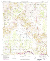
1947 Map of Forkland
USGS Topo · Published 1984About this map
The Tombigbee River forms a significant bend at the base of this landscape, marking the boundary between Greene and Sumter counties. The southern portion of the map is defined by the extensive Hagan Swamp and a network of creeks including McConnico Creek and Taylor Creek. The St Louis San Francisco railroad cuts diagonally across the center, passing the Thornhill Sta and the settlement of Thornhill.
Find a feature on this map
48 named features on this map. Tap any name to fly to it.
Don’t see what you’re looking for? This feature index may not catch every label — zoom into the map to look around manually.
Map Details
Editions of this 1947 Forkland Map
3 editions found
Other maps of this area

1927 · Eutaw
USGS Topo · 1:48,000

1929 · Epes
USGS Topo · 1:48,000

1931 · Eutaw
USGS Topo · 1:62,500

1932 · Epes
USGS Topo · 1:62,500

1946 · Demopolis
USGS Topo · 1:24,000

1947 · Demopolis
USGS Topo · 1:24,000

1947 · Mason Bend
USGS Topo · 1:24,000

1947 · Forkland
USGS Topo · 1:24,000

1948 · Mason Bend
USGS Topo · 1:24,000

1948 · Mc Dowell
USGS Topo · 1:24,000