
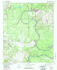
1947 Map of Mason Bend
USGS Topo · Published 1948About this map
The Black Warrior River dominates this mid-century landscape, carving deep oxbows and bends along the border of Greene and Hale counties. This 1947 revision reveals a rural economy centered on the river and its fertile floodplains, marked by numerous landings and quarters such as Walden Quarters and Jackson Quarters. The importance of the waterway for transport is evidenced by Lock No 6 and various riverfront sites like Lake Bend Landing and East Port Landing.
Find a feature on this map
48 named features on this map. Tap any name to fly to it.
Don’t see what you’re looking for? This feature index may not catch every label — zoom into the map to look around manually.
Map Details
Editions of this 1947 Mason Bend Map
2 editions found
Other maps of this area

1927 · Eutaw
USGS Topo · 1:48,000

1931 · Eutaw
USGS Topo · 1:62,500

1946 · Demopolis
USGS Topo · 1:24,000

1947 · Demopolis
USGS Topo · 1:24,000

1947 · Forkland
USGS Topo · 1:24,000

1948 · Mason Bend
USGS Topo · 1:24,000

1948 · Mc Dowell
USGS Topo · 1:24,000

1949 · Mc Dowell
USGS Topo · 1:24,000

1949 · Forkland
USGS Topo · 1:24,000

1953 · Montgomery
USGS Topo · 1:250,000