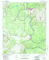
1947 Map of Mason Bend
USGS Topo · Published 1987About this map
The Black Warrior-Tombigbee Waterway defines the landscape of this western Alabama region, carving deep meanders like Mason Bend and Erie Bend through the bottomlands. The map reveals a post-war rural landscape where navigation and agriculture intersect, evidenced by numerous river access points such as East Port Landing and Millwood Landing, alongside the infrastructure of Old Lock No 6.
Find a feature on this map
60 named features on this map. Tap any name to fly to it.
Don’t see what you’re looking for? This feature index may not catch every label — zoom into the map to look around manually.
Map Details
Editions of this 1947 Mason Bend Map
2 editions found
Other maps of this area

1927 · Eutaw
USGS Topo · 1:48,000

1931 · Eutaw
USGS Topo · 1:62,500

1946 · Demopolis
USGS Topo · 1:24,000

1947 · Demopolis
USGS Topo · 1:24,000

1947 · Mason Bend
USGS Topo · 1:24,000

1947 · Forkland
USGS Topo · 1:24,000

1948 · Mason Bend
USGS Topo · 1:24,000

1948 · Mc Dowell
USGS Topo · 1:24,000

1949 · Mc Dowell
USGS Topo · 1:24,000

1949 · Forkland
USGS Topo · 1:24,000