Loading...
Loading map...1929 Map of Epes
USGS Topo · Published 1929About this map
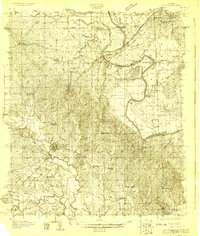
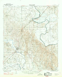
The Tombigbee River and the Alabama Great Southern railroad define the landscape of this 1929 survey, tracing the border between Greene and Sumter counties. At Livingston, the county seat, the detailed street grid and the Colored Industrial School signify a hub of education and regional transit. To the north, the river winds past Mc Alpin Bend and Jones Bluff, where ferries like Hillman Ferry once provided essential crossings before modern bridges dominated the corridor.
Find a feature on this map
57 named features on this map. Tap any name to fly to it.
Don’t see what you’re looking for? This feature index may not catch every label — zoom into the map to look around manually.
Map Details
Date Portrayed1929
Date Published1929
PublisherU.S. Geological Survey
Map TypeTopographic
Scale1:48,000
Physical Dimensions22.7 x 26.8 inches
Editions of this 1929 Epes Map
This is the sole edition of this map. No revisions or reprints were ever made.
Historical Maps of Livingston Through Time
Featured Locations
Source Details
SourceU.S. Geological Survey
CopyrightPublic Domain