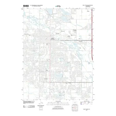
2010 Map of Fort Collins
USGS Topo · Published 2010About this map
The Cache la Poudre River winds through this northern Colorado landscape, serving as the historical lifeline for a sophisticated network of irrigation works including the Larimer and Weld Canal, Boxelder Ditch, and Mail Creek Ditch. This early 21st-century map illustrates the dense urban expansion of Fort Collins, radiating from the Colorado State University campus toward outlying settlements like Buckingham and Andersonville. The map reflects a community shaped by both agricultural heritage and modern utility, evidenced by numerous named reservoirs like Warren Lake and Long Pond Reservoir, as well as industrial features such as the Fort Collins Quarry. Genealogists will find particular value in the clearly marked Grandview Cemetery, Roselawn Cemetery, and Harmony Cemetery, while aviation history is preserved through the Downtown Fort Collins Airpark and Valley Airpark.
Find a feature on this map
59 named features on this map. Tap any name to fly to it.
Don’t see what you’re looking for? This feature index may not catch every label — zoom into the map to look around manually.
Map Details
Editions of this 2010 Fort Collins Map
This is the sole edition of this map. No revisions or reprints were ever made.
Other maps of this area

1902 · Greeley
USGS Topo · 1:125,000

1906 · Loveland
USGS Topo · 1:62,500

1906 · Fort Collins
USGS Topo · 1:62,500

1907 · Livermore
USGS Topo · 1:125,000

1908 · Loveland
USGS Topo · 1:62,500

1908 · Fort Collins
USGS Topo · 1:62,500

1908 · Eaton
USGS Topo · 1:125,000

1909 · Livermore
USGS Topo · 1:125,000

1910 · Eaton
USGS Topo · 1:125,000

1950 · Windsor
USGS Topo · 1:24,000