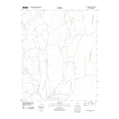
2010 Map of Fort Defiance
USGS Topo · Published 2010About this map
Fort Defiance serves as the primary hub of this high-desert landscape, situated where the Black Creek drainage meets the southern reaches of the Chuska Mountains. The settlement’s modern infrastructure is defined by a network of local roads including Kit Carson Dr and Old Sawmill Rd, illustrating the intersection of government administration and community development. To the west, the deep incisions of Bonito Canyon and its associated waterways like Meadow Wash and Cold Spring Wash reveal the complex hydrology required to sustain life in this arid environment.
Find a feature on this map
24 named features on this map. Tap any name to fly to it.
Don’t see what you’re looking for? This feature index may not catch every label — zoom into the map to look around manually.
Map Details
Editions of this 2010 Fort Defiance Map
This is the sole edition of this map. No revisions or reprints were ever made.
Other maps of this area

1886 · Wingate
USGS Topo · 1:250,000

1886 · Fort Defiance
USGS Topo · 1:250,000

1892 · Fort Defiance
USGS Topo · 1:250,000

1892 · Wingate
USGS Topo · 1:250,000

1954 · Gallup
USGS Topo · 1:250,000

1955 · Zith-Tusayan Butte 4 NW
USGS Topo · 1:24,000

1955 · Zith-Tusayan Butte 4 NE
USGS Topo · 1:24,000

1955 · Zith-Tusayan Butte 1 SE
USGS Topo · 1:24,000
1955 · Zith-Tusayan Butte 1 NE
USGS Topo · 1:24,000
1955 · Zith-Tusayan Butte 1 NW
USGS Topo · 1:24,000